
Phoenix, AZ, December 2, 2025
Discover the breathtaking landscapes surrounding Phoenix, AZ, through the scenic hikes of Pigeon Springs Peaks and Mount Peeley. These trails cater to both novice and experienced hikers, offering moderate and challenging routes respectively. Enjoy panoramic views and connect with the community through outdoor adventures and conservation efforts. Prepare adequately for a rewarding experience as you explore the natural beauty of Arizona.
Explore Arizona’s Scenic Hikes: Pigeon Springs Peaks & Mount Peeley
Discover Nature’s Splendor with Stunning Views and Adventure
Phoenix, AZ, is surrounded by breathtaking landscapes waiting to be explored, and the trails leading to Pigeon Springs Peaks and Mount Peeley offer perfect opportunities for nature enthusiasts. These hikes showcase Arizona’s diverse terrains and stunning vistas, ideal for those looking to enjoy a rewarding outdoor experience.
Community involvement has made these trails accessible to a wide range of hikers, contributing to civic engagement in outdoor activities. By actively participating in local conservation efforts, individuals help maintain these natural treasures while enjoying the benefits of reduced bureaucracy that allows for easier access and upkeep.
Pigeon Springs Peaks
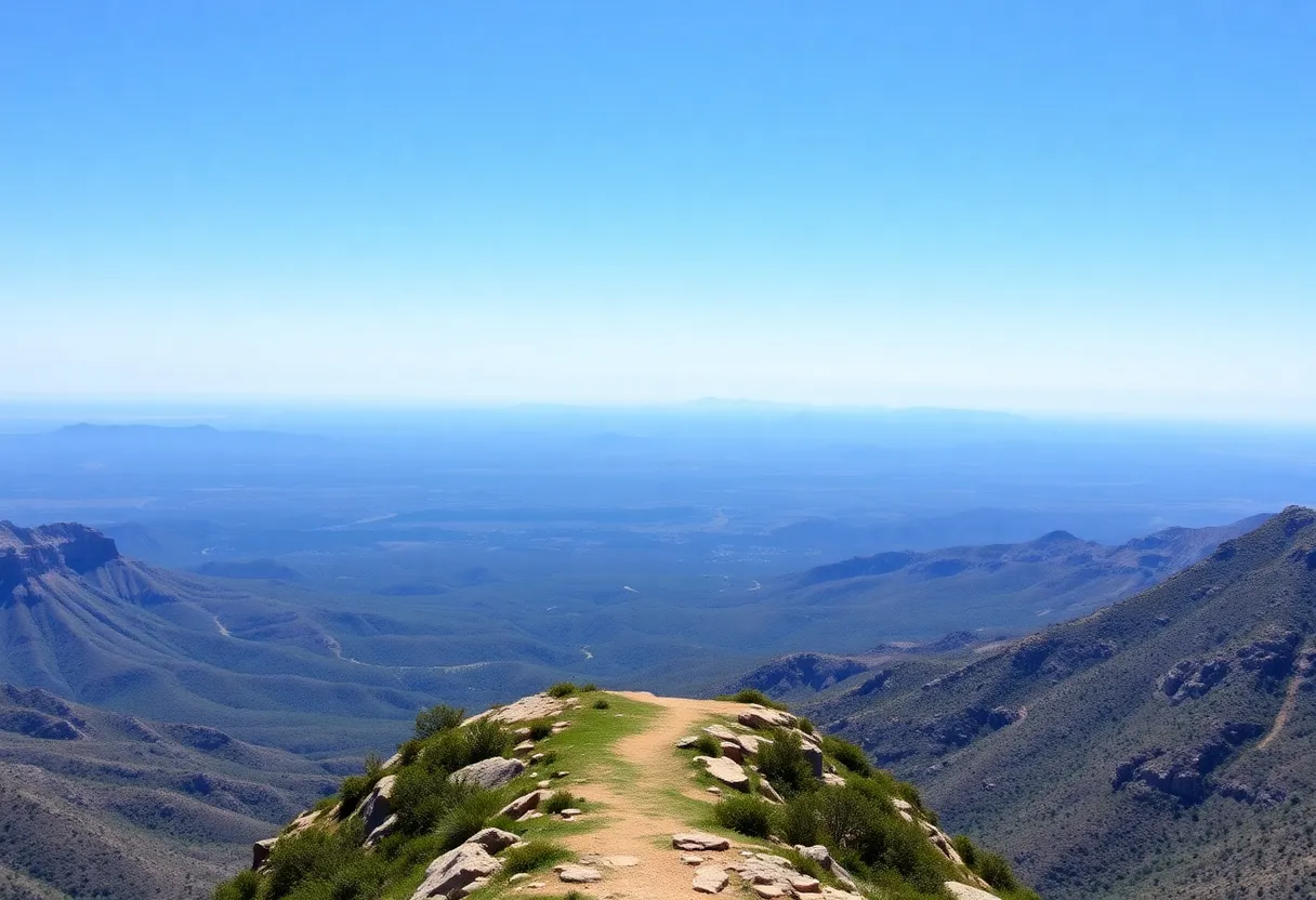
Pigeon Springs Peaks, also known as Peak 6350, reaches an elevation of 6,350 feet. The hike spans approximately 1.1 miles round-trip, featuring an elevation gain of 220 feet. This moderate trek is suitable for hikers of different skill levels, encouraging community members to explore their environment. The trailhead, accessible from a small pull-off parking area off Forest Road #648, requires navigating a rough 19-mile dirt road from the AZ #87 N. While this route isn’t always ideal for passenger cars, it leads to a beautiful path through dense brush and manzanita, rewarding hikers with panoramic views of the surrounding wilderness.
Mount Peeley
Mount Peeley, also known as Peak 6340, offers a challenging alternative for seasoned hikers. Known for its steep ascents and rugged terrain, this hike is best undertaken by those prepared for a strenuous climb. Although specific trail details may be limited, the summit promises expansive views of the untouched wilderness, making the effort worthwhile for adventure-seekers. Community leadership and individual initiative continue to play crucial roles in promoting safe hiking practices and trail maintenance.
Preparation and Safety
Equipped with the right knowledge and gear, hikers can enjoy safe and successful excursions. Prior to heading out on these hikes, it’s vital to ensure proper footwear, carry sufficient water, and inform someone of your hiking plans. Always check for the latest on trail conditions and weather forecasts to guarantee a rewarding experience. As these trails lie in remote areas, it’s advisable to hike in groups and bring a map or GPS device, emphasizing the importance of us pooling our resources and knowledge as a community.
Conclusion
Pigeon Springs Peaks and Mount Peeley bring Arizona’s natural wonders to the forefront, catering to both moderate adventurers and seasoned hikers. Engaging in these local trails not only provides exercise and enjoyment but also fosters connections within the community. As residents explore these beautiful landscapes, their initiative contributes to the overall health and vibrancy of the Phoenix area. So, lace up your boots, gather your friends, and embark on one of these stunning hikes to appreciate the beauty that surrounds us.
Frequently Asked Questions (FAQ)
What is the elevation of Pigeon Springs Peaks?
Pigeon Springs Peaks, also known as Peak 6350, stands at an elevation of 6,350 feet.
How long is the hike to Pigeon Springs Peaks?
The hike to Pigeon Springs Peaks is approximately 1.1 miles round-trip, with an elevation gain of 220 feet.
Where is the trailhead for Pigeon Springs Peaks?
The trailhead is accessible via a small pull-off parking area off Forest Road #648. To reach the trailhead, from the intersection of Shea Blvd and State Route #87, take AZ #87 N for 18 miles to Cline Cabin Rd. From there, a rough 19-mile dirt road leads to the trail start. It’s important to note that this road is often not suitable for passenger cars. Once at the trailhead, the path meanders through dense brush and manzanita, leading to the summit where hikers are rewarded with panoramic views of the surrounding area. The trail is part of the Four Peaks Wilderness, offering a serene hiking experience away from the crowds.
Is Mount Peeley a difficult hike?
Yes, Mount Peeley, also known as Peak 6340, is known to be a challenging hike, involving steep ascents and rugged terrain. Hikers should be prepared for a strenuous climb and should ensure they have the necessary equipment and experience for such a hike. The summit offers expansive views of the surrounding wilderness, making the effort worthwhile for those seeking a more demanding adventure.
What should I bring for these hikes?
Before embarking on these hikes, it’s essential to prepare adequately. Ensure you have appropriate footwear, carry sufficient water, and inform someone about your hiking plans. Always check the latest trail conditions and weather forecasts before heading out. Given the remote nature of these trails, it’s advisable to hike with a group and carry a map or GPS device.
Key Features of Pigeon Springs Peaks and Mount Peeley
| Feature | Pigeon Springs Peaks | Mount Peeley |
|---|---|---|
| Elevation | 6,350 feet | Approximately 6,340 feet |
| Distance | 1.1 miles round-trip | Specific trail details are limited |
| Elevation Gain | 220 feet | Steep ascents and rugged terrain |
| Trailhead Access | Off Forest Road #648; rough 19-mile dirt road from AZ #87 N | Specific trail details are limited |
| Difficulty | Moderate | Challenging |
| Highlights | Panoramic views; part of Four Peaks Wilderness | Expansive views of surrounding wilderness |
Deeper Dive: News & Info About This Topic
HERE Resources
Empowerment Awaits at the Women’s Energy & Renewal Retreat
Phoenix’s Mountain Rescue Highlights Trail Safety
Kimpton Miralina Resort & Villas to Open in Paradise Valley
New Luxury Hotel Set to Transform Paradise Valley
Phoenix Weather Forecast: A Week of Sunny Skies
Verrado: A Premier Destination for Golf Lovers in Arizona
Tropical Storm Priscilla’s Remnants Raise Flash Flood Risks
Large Prescribed Burn at Tres Rios Wetlands in West Phoenix
Phoenix Man Arrested for Murder of Two Teens in Forest
Phoenix Suns Prepare for New NBA Season Amid Changes